
This article is inspired by the recent Earthquake in Cebu, Philippines of Magnitude 6.9.
The Philippine archipelago was formed as a result of the collision of the Eurasian Plate on the west and the Pacific Plates in the east, which subsequently also formed the Philippine Plate. In other words, the entire archipelago was born out of earthquakes.
Earthquakes are so common in parts of the archipelago that it became a part of ancient Filipinos’ mythology. There are at least five deities in Philippine mythology that were said to cause earthquakes. The Ifugaos have a god, Kolyog, who is believed to be responsible for earthquakes. Kolyog is considered by Ifugaos as the spirit of earthquakes.

Panlinugun, a Visayan deity, is considered as the god of the Underworld and of Earth and is believed to cause earthquakes.
Lakanapi is a fire god known to ancient Kapampangans as a dragon serpent that moves in the veins of the Indung Tibuan, the mother earth goddess, causing her to move and produce earthquakes.
Dumakulem, a god in Tagalog mythology, is known as the sky god who creates mountains. Ancient Tagalogs believed that whenever there was an earthquake, Dumakulem was creating mountains. It is remarkable how ancient Tagalogs associated earthquakes with the creation of mountains, which is scientifically true.
These various mythological beliefs point to the fact that ancient Filipinos are no stranger to frequent earthquakes, which they have incorporated into their rich cultural heritage. As scientific knowledge advanced, these beliefs gradually faded.
In a span of only 50 years, the Philippines has had thousands of earthquakes with significant magnitude that was recorded. I remember some of the worst earthquakes that devastated the Philippines as follows:.
1990 Luzon Earthquake: It was late Monday afternoon and people were just preparing to go home from work when tragedy struck: a magnitude 7.8 earthquake shook Luzon, with its epicenter in Nueva Ecija. Its effects were most felt in Baguio, Cabanatuan, Dagupan, and La Union.Baguio suffered the most damage – the earthquake collapsed 28 buildings, damaged roads, and caused landslides that blocked Kennon Road and Marcos Highway, the two main roads to access Baguio from the capital. It virtually cut off Baguio from relief, and the only way to go in was by air.
People were buried alive inside collapsed high-rise buildings, including the Hyatt Terraces Plaza, Baguio Park Hotel, and Baguio Hilltop Hotel. Some survivors in these buildings were miraculously rescued two weeks after the earthquake – after international rescue teams left the site assuming there were no more survivors.
In Cabanatuan, a six-storey school building collapsed during class hours, taking the lives 154 people inside. Dagupan City also suffered extensive damage, with 90 buildings having cracks or fractures, and another 20 collapsed buildings. In La Union, 100,000 families were evacuated when several villages sank due to liquefaction. In total, the 1990 Luzon Earthquake took 2,412 lives and affected an area of 20,000 square kilometers.
1968 Casiguran Earthquake: Casiguran is a municipality in Aurora Province, 200 kilometers from Manila. On August 2, 1968 at 4:19 A.M., a magnitude 7.3 earthquake jolted the province, but most of the casualties were in Manila. According to Phivolcs, the earthquake killed 270 people – one in Aurora, Quezon, one in Guagua, Pampanga, and 268 in Manila.
1976 Moro Gulf Earthquake: On August 17, 1976, at ten minutes past midnight while people were sound asleep, a magnitude 8.0 earthquake rocked Mindanao. Its epicenter was detected in the Cotabato Trench, which generated a tsunami. According to PHIVOLCS, the tsunami was responsible for 85 percent of deaths, 65 percent of injuries, and 95 percent of missing persons.
The tsunami flattened towns and villages along the 700 kilometers of coastline bordering the Moro Gulf in the Celebes Sea. It swept away people, animals, and property. The 1976 Moro Gulf Earthquake is remembered as one of the worst disasters in the Philippines owing to the high number of deaths, injuries, and missing persons it caused. A total of 4,791 people died, 2,288 went missing, and 9,928 were injured. Another 93,300 were left homeless.
2013 Bohol Earthquake1976 Moro Gulf Earthquake
On August 17, 1976, at ten minutes past midnight while people were sound asleep, a magnitude 8.0 earthquake rocked Mindanao. Its epicenter was detected in the Cotabato Trench, which generated a tsunami. According to PHIVOLCS, the tsunami was responsible for 85 percent of deaths, 65 percent of injuries, and 95 percent of missing persons.
The tsunami flattened towns and villages along the 700 kilometers of coastline bordering the Moro Gulf in the Celebes Sea. It swept away people, animals, and property. The 1976 Moro Gulf Earthquake is remembered as one of the worst disasters in the Philippines owing to the high number of deaths, injuries, and missing persons it caused. A total of 4,791 people died, 2,288 went missing, and 9,928 were injured. Another 93,300 were left homeless.
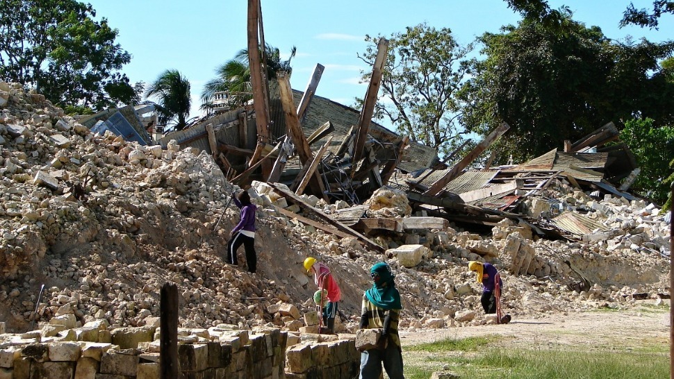
2012 Negros Oriental Earthquake. On the afternoon of February 6, 2012, a magnitude 6.9 earthquake shook the islands of Negros, Cebu, and islands in the Western Visayas Region. The earthquake caused major landslides and huge cracks on highways, killing at least 52 people in Negros Island and Cebu Province. While the human fatalities are relatively low compared with other earthquakes of the same magnitude affecting densely populated areas, the damage it dealt to the infrastructure and surrounding geography was calamitous.
- 2. 2024 Caraga earthquake (magnitude 6.8): Occurred in the Caraga region.
- 3. November 2023 Mindanao earthquake (magnitude 6.7): A deadly offshore quake.
- 4. December 2019 Mindanao/Davao earthquake (magnitude 6.8): A fatal quake that killed 13 people.
- 5. July 2022 Luzon earthquake (magnitude 7.1): A powerful quake felt in Manila that killed 11 people.
- 6. July 2021 Luzon earthquake (magnitude 6.7): A deep earthquake off the coast of Luzon.


- Date & Time: January 25, 1948, at 1:46 AM.
- Magnitude: 8.2 Ms.
- Epicenter: Southwest of Panay Island, between the municipalities of Anini-y and Dao (now Tobias Fornier) in Antique province.
- Nickname: Lady Caycay earthquake.
- Destruction: Widespread damage was reported across Panay and neighboring islands.
- Damage to Structures: The historic Oton Church was severely damaged and demolished, and the five-story belfry of the Jaro Cathedral collapsed.
- Tsunami: The earthquake also triggered a tsunami that caused some deaths.
- Fissures: Eyewitnesses reported large fissures in the earth that sprayed water and sand.
- Loss of Life and Injuries: Reports indicate at least 27 deaths and many injuries, with other figures stating a total of 74 deaths, including those from the tsunami.
- Economic Impact: The disaster resulted in approximately £100,000 (or $3.5 million in 1948 currency) in damages.
- Population Displacement: Many people were displaced, leading to migration and reshaping the demographics of affected areas.
- Cultural Heritage: The destruction of historic churches and landmarks resulted in significant heritage loss.
No comments:
Post a Comment